


Directions to Camp
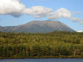
If you are coming through a little early and it is a nice clear day, it may be worth the extra drive up I-95 to Mile 251, where there is a scenic turnout of Mt. Katahdin. After, continue North to Houlton and follow directions below.
From: I-95 Exit 227 Lincoln approx. 55 miles
From I-95 take Exit 227 to Lincoln make left at first light, then go past Wal-Mart to 3rd light at Rite-Aid and soldier monument make a left continue thru town of Lincoln and bear left at "Y" on Rt. 2 continue thru towns of Winn, Mattawamkeag, and Macwahoc where you get off Rt.2 and onto RT. 2A. This is a straight at intersection. Continue on through the town of Reed and onto Haynesville approximately 19 miles, there is no town sign only a few homes and a church on right watch for signs of Sweden Rd. & Danforth Rd. after which you will cross a small bridge (Mattawamkeag River) continue along about 12 miles our sign is on right across from the first utility pole.
From: I-95 Houlton & New Brunswick
South on Rt. 1 thru Houlton cross bridge at light make right onto Rt. 2A South (Military Rd.) continue approximately 8 miles thru Linneus approximately 3.3 miles from the flashing light at the 4-way intercetion. Our sign is on the left, across the raod from the last utility pole entering TA R2 WELS.
GPS Address
Due to the Remote location of our camp and the different manufacturers of GPS's there are several different addresses that may work. Try any of the following:
2507 Bangor Road, Linnues, Maine
2507 US Route 2A, Linneus, Maine
2507 US-2A, Linneus, Maine